Colorado was the lucky recipient of historic snow falls early in March, 2019. Then during the middle of March the onslaught of historic Winter weather continued with a rare mid-latitude mid-continent cyclone, one that would undergo a process of rapid intensification called Bombogenesis, or Bomb Cyclogenesis.
Here is a collection of some of the news stories and video about the storm and some of the resulting avalanches and snow drifts.
To set the picture, the Weather Channel reported on Mar. 11, 2019:
‘Incredible and Daunting:’ Avalanches Cut Off Colorado Town From Everything South of It
Mar. 11, 2019 – weather.com – By Ron Brackett
An “incredible and daunting” amount of snow has closed a highway in southwest Colorado virtually shutting off the town of Ouray from everything south of it. Ouray, pronounced U-ray, is in the Red Mountain Pass area along U.S. 550, about 185 miles southwest of Denver.
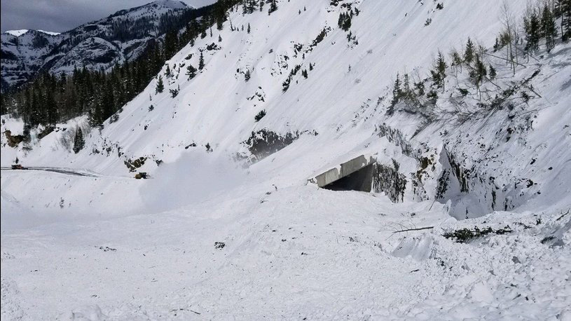
On Friday [March 8], the Colorado Department of Transportation began clearing debris and snow from earlier avalanches that had blocked the highway. Officials expected the pass to reopen soon. Then on Saturday, the department conducted helicopter avalanche control operations on 20 avalanche paths in the area. That added massive amounts of snow and debris to the stuff already piled on the road from the earlier snow slides. Snow rises as high as 60 feet over a 300-foot section of the highway. “We are describing it as ‘incredible and daunting’ and it will keep US 550 Red Mt. Pass CLOSED,” the department said in a Facebook post.
How long will the 23-mile stretch of highway between Ouray and Silverton be closed? “Indefinitely, until they can get all that 60 feet of snow moved out of the way,” Ouray Mayor Pam Larson told The Weather Channel in an interview Tuesday evening. Larson said the town of about 1,000 people has been shut off for days before because of avalanches and snow slides, but this year has seen historic snowfall.
Avalanche danger reached extreme levels earlier this month. On Tuesday, the Colorado Avalanche Information Center issued an avalanche warning and said the danger in the mountains near Ouray was at the high level. Mayor Larson said even though the highway remains open north of town, some motels are losing business that would arrive from Silverton or Durango in the south.
She said a bigger problem for the town right now is where to put all the snow that is being cleared from roads. “Nearly every corner in town is piled high,” she said. It’s not going to get any better this week. Brian Donegan a weather.com meteorologist said Ouray can expect around a foot of new snow from Winter Storm Ulmer. A winter storm warning is in effect until 6 a.m. MDT Thursday.
Highway 550
Avalanche Mitigation Brings 60 Feet Of Snow & Debris, Closes U.S. 550 Indefinitely
CBS4 Denver, Mar. 10, 2019
SAN JUAN/OURAY COUNTY, Colo. (CBS4) – Avalanche mitigation in southwest Colorado has forced the indefinite closure of U.S. 550, also known as Red Mountain Pass. The Colorado Department of Transportation says they addressed 20 avalanche paths on three passes on Saturday.[Note: Highway 550 connects Ouray with Silverton via Red Mountain Pass.

Facebook Video – Incredible aerial video from CDOT flying over Red Mountain Pass today in the San Juan Mountains. Red Mountain Pass is closed indefinitely. It’s avalanche after avalanche covering the road. CDOT mitigated 20 avalanche paths this weekend. You’re looking at the Brooklyns Slide and others burying highway 550. – Chris Tomer, Colorado’s Own Channel 2 and FOX31 Denver. Video: CDOT
RED MOUNTAIN PASS – Extended Closure (720p)
Colorado Department of Transportation
Published on Mar 21, 2019 (YouTube Video)
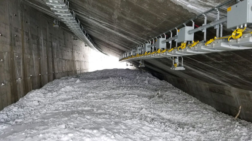
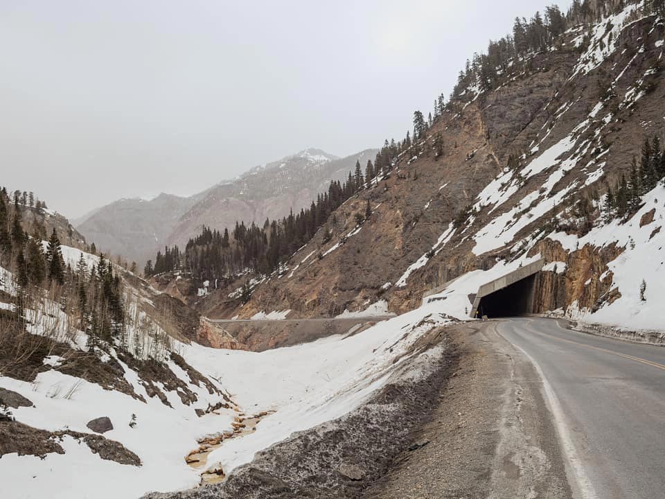
US 550 Red Mt. Pass is a major mountain highway in southwest Colorado. The high-country mountain corridor links the mountain communities of Silverton and Ouray. The highway is part of the San Juan Skyway (scenic byway) and is also known as the “Million Dollar Highway.” Footage of US 550, Red Mt. Pass, traveling north from Silverton to Engineer Pass Rd. (seen at 8:40), then views of the highway returning back, south to Silverton. Severe snowstorms and epic avalanche activity have closed this highway, located in southwest Colorado, since Sunday, March 3, 2019. This video was captured on March 15, immediately following avalanche mitigation operations intended to knock down potential existing avalanches and snow slides that have kept road maintenance crews from working on the highway. Mitigation efforts were successful, and crews can now work safely (from avalanche danger) to clear snow and debris from the roadway. Operations are expected to be slow-going because many of the snow slides are “dirty,” containing rocks, limbs and even trees brought down from the mountain sides.
—Colorado Department of Transportation

Highlands Ridge
Massive Avalanche Near Aspen Saturday Was Mile Wide, Dropped 3,300 Feet (Highlands Ridge Avalanche)
CBS4 Denver, Mar. 10, 2019
PITKIN COUNTY, Colo. (CBS4) – Colorado remains in the middle of a historic avalanche cycle due to a series of winter storms that dropped 4 to 8 feet of snow in less than 10 days in the mountains. Hundreds of avalanches have been reported, some large enough to close major highways.

‘Historic-sized’ avalanche hits Conundrum Valley southwest of Aspen: Mile-wide slide breaks near Aspen Highlands ski area; home saved by barricade.
The Aspen Times, March 10, 2019
By Scott Condon

An avalanche off Highlands Ridge over the weekend deposited tons of snow in Conundrum Creek Valley, snapped hundreds of mature trees and threatened a house.
“This is as big of an avalanche as this terrain can produce,” said Brian Lazar, deputy director of the Colorado Avalanche Information Center. “This is a landscape-changing event.”
The avalanche broke over a mile wide and ran more than 3,000 vertical feet downhill, CAIC estimated from aerial observations. Lazar said it started just outside the boundary of Aspen Highlands ski area.
The slide went down two popular backcountry ski routes off Highlands Ridge — K Chutes and Five Fingers. It likely slid across the vast area all at once, Lazar said. Officials believe it was a natural releasing avalanche that occurred sometime late Friday or early Saturday [March 8 or 9].
The snow and debris fell with such force that it kept going once it hit the valley floor, traveling a couple hundred feet up the east slope and then spilling downvalley.
Read the remainder of the article »
Avalanche expert says Conundrum slide likely a 300-year event
The Aspen Times, March 12, 2019
By Scott Condon

A massive slide that swept down from Highlands Ridge into Conundrum Creek Valley last weekend was probably a 300-year event, a leading avalanche consultant said Tuesday while touring the site.
“This is definitely a big one for Colorado,” said Art Mears while surveying the volume of snow and debris the avalanche deposited. The only comparable slide he has seen in Colorado struck the Gothic area near Crested Butte in 1995, he said.
Mears is an engineer from Gunnison who consults with governments and individuals to locate infrastructure and buildings where they will avoid avalanches. When structures are built in avalanche-prone areas, he helps create designs to mitigate the risk. He has worked on 1,100 projects in nine states and eight countries. He has designed several avalanche mitigation systems for homes in Pitkin County, including a “splitting wedge” concrete wall that probably saved a house at 1053 Conundrum Creek Road from getting flattened by last weekend’s slide.
Read the remainder of the article and watch the video »
The Bomb Cyclone of March, 2019 – a.k.a. Winter Storm Ulmer
Bomb Cyclone makes history, breaks records:
Historic storm brings blizzard conditions to seven states, breaks records for intensity, snowfall, rainfall, and causes historic flooding
9News.com, March 16, 2019
By Cory Reppenhagen

COLORADO, USA — The ingredients for this historic cyclone started coming together on March 12, 2019. A trough of low pressure, that had been dropping south down the coast of California for a couple days, got cut off near the Baja Peninsula. It then picked up guidance from the Sub-Tropical Jet Stream.
As that cutoff low started moving northeast on the morning of March 12, it was flanked to the north by a new trough starting to bend in the Polar Jet Stream.
These two features would meet up on March 13, to form a monster cyclone on the lee side of the Rocky Mountains.
The Bomb
The mid-latitude cyclone would undergo a process of rapid intensification called Bombogenesis, or Bomb Cyclogenesis, which is when a cyclone drops 24 millibars or more of surface pressure in 24 hours or less.
The greatest 24-hour drop in surface pressure was 33 mb or 1 inch of pressure at 9 a.m. MDT on March 13. It even bombed out in the Denver area. NCAR in Boulder, Colorado measured a 27 mb pressure drop in 24 hours. It is rare for a cyclone to experience this type of rapid intensification in the middle of the country. It is a little more common closer to the Atlantic coast, but even then, it is a rare process.
Read the remainder of the article »
The same storm system that inundated Colorado traveled East and had a significant impact on several states as reported by The Weather Channel on Mar. 13, 2019. (The satellite image above shows the position of the storm late in the day on March 13.)

Winter Storm Ulmer, the March 2019 Bomb Cyclone, Blasted the Plains With Blizzard Conditions, High Winds
Mar. 13, 2019 – By weather.com meteorologists
Winter Storm Ulmer was a blizzard that paralyzed travel in parts of the Plains, produced damaging winds in some places that didn’t pick up any snow, triggered massive, record-breaking Plains flooding, and set new low-pressure records as a bomb cyclone.
Winter Storm Ulmer was named on the afternoon of March 11, with the expectation that areal criterion – that is, 400,000 square kilometers (248,548 square miles) under winter storm warnings – would be met the following day. That criterion was achieved by the morning of March 12.
Ulmer’s genesis began with two distinct disturbances that rolled down the West Coast on March 10. The first and more potent low rolled down the California coast from near San Francisco to northern Baja California March 10-11 as the second, weaker system arrived in the Pacific Northwest.
Ulmer brought snow to parts of the Pacific Northwest, mountains of Southern California and the Four Corners region March 11-12 before spreading eastward into the Rockies and Plains.
6 Images That Show How the Latest ‘Bomb Cyclone’, Winter Storm Ulmer, Came to Be
March 12, 2019 – weather.com – By Chris Dolce
These weather images show how the storm became so strong.
Meteorologists are often fascinated by eye-popping weather imagery from extreme weather events, and Winter Storm Ulmer, dubbed the ‘bomb cyclone’ by some, is no different.
Ulmer’s low-pressure system has become unusually intense for a storm system in the Plains. It’s a rare example of bombogenesis for that region of the country, meaning the atmospheric pressure dropped 24 millibars or more in 24 hours.
The image above shows the rapidly-falling atmospheric pressure over the course of three hours in the central Plains on Wednesday morning. This largest pressure falls, shown in light red, are in eastern Colorado, Kansas and Nebraska.


It was a hell of a Winter!