“High Above Ukraine, Satellites Get Embroiled in the War”
WIRED, March 4, 2022
Business
By Morgan Meaker
“While the Russian invasion rages on the ground, companies that operate data-collecting satellites find themselves in an awkward position.”
The traffic jam stretched from the Russian city of Belgorod to the Ukrainian border. Google Maps marked the congestion with red and orange, just as it does in all countries where the app is used to track traffic. But the GPS satellites sending these vehicles’ positions to Google were not picking up an ordinary traffic jam. This was 40 kilometers of traffic caused by Russian troops.
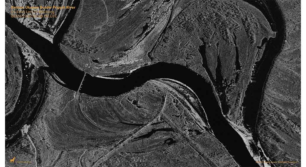
That convoy turned out to be an early warning that the Russian troops amassed on Ukraine’s borders were on the move. It was first noticed at 3:15 am on Thursday of last week by Jeffrey Lewis, a professor at the Middlebury Institute of International Studies (MIIS), a graduate school in California—hours before reports of Ukraine’s first explosions filtered into the news. But he did not stumble on it by accident. Lewis had a tip-off from a radar image taken by a commercial satellite company called Capella Space, which showed Russian troops lined up along the road in columns near Belgorod. “When the Russians are camping for a long time they park their tanks in a square and they put up tents,” says Lewis.
But this satellite image showed troops in a very different formation. There were no tents; they were ready to move. When one of Lewis’ colleagues started searching for the routes this column might take to move toward Ukraine, he found the traffic jam. “It’s really a story about fusing different kinds of data,” says Lewis.
Then, on February 28, Google said it would temporarily turn off live traffic updates in Ukraine “after consulting with multiple sources on the ground, including local authorities.” Google did not elaborate on why it was worried about the feature. But researchers speculate the company is concerned that traffic data revealing the location of troops or refugees could be used to inform military strikes. “You can understand why Google would not want to be a party to providing targeting data in an international conflict,” says Lewis.
In the sky above Ukraine right now are around 50 working satellites, estimates Todd Humphreys, a professor at the University of Texas. Those satellites have become a key part of Ukraine’s efforts to fend off a Russian invasion. The government there has been pleading for satellite images for clues of where Russian troops might move next.
About the Author:
Morgan Meaker is a senior writer at WIRED covering European business. Before that, she was a technology reporter at The Telegraph and also worked for Dutch magazine De Correspondent. In 2019 she won Technology Journalist of the Year at the Words by Women Awards. She was born in Scotland, lives in London, and is a graduate of City University’s International Journalism MA program.